


 分享至
分享至


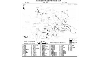
东北地区水环境参数遥感监测与反演研究进展
中科院东北地理与农业生态研究所地理景观遥感学科组在东北地区内陆湖泊水质参数遥感反演、地表实际蒸散遥感估算等方面取得系列研究进展,相关研究成果发表在遥感、环境科学和生态学领域的国际主流学术期刊。
学科组应用经验模型、半解析模型、GA-PLS智能算法,对东北地区重要内陆湖泊和城市水源地的叶绿素含量、总悬浮物含量等水质参数进行了遥感监测与空间反演[1-4],这些研究结果为东北地区内陆水体富营养化与蓝藻爆发的实时遥感监测提供理论与技术支撑,同时也为其他地区湖泊富营养化遥感监测与动态分析提供了技术支撑。课题组深入开展内陆水体固有光学特性研究,为生物光学模型的实现奠定基础[5]。基于SEBAL模型与MODIS遥感数据产品,对松嫩平原地表实际蒸散量ET进行估算,为松嫩平原农业生产水分管理提供依据[6],可为农业水分利用效率空间决策提供可视化依据。
以上研究工作得到中国科学院知识创新工程重要方向项目(KZCX2-YW-340)、(KZCX2-YW-QN305)、国家自然科学基金项目(41171293)的资助。
相关论文:
[1] Song, K. S., Wang, Z. M., Blackwell, J., Zhang, B., Zhang, Y. 2011. Water quality monitoring using Landsat Thematic Mapper data with empirical algorithms in Chagan Lake, China. Journal of Applied Remote Sensing, 5. Doi:10.1117/1.3559497.
[2] Song, K.S., Lu, D.M., Li, L., Li, S., Wang, Z.M., Du, J. 2011. Remote sensing of chlorophyll-a concentration for drinking water source using genetic algorithms (GA)-partial least square (PLS) modeling. Ecological Informatics. In press, DOI: 10.1016/j.ecoinf.2011.08.006.
[3] Song, K.S., Wang, Z.M., Liu, D.W., Zhang, B., Xu, J.P., Du, J., Li, L.H., Li, S., Wang, Y.D. 2011. Retrieval of total suspended matter (TSM) and chlorophyll-a (Chl-a) concentration from remote-sensing data for drinking water resources. Environmental Monitoring and Assessment. in press, DOI: 10.1007/s10661-011-2053-3.
[4] Jiang, G.J., Liu, D.W., Song, K.S., Wang, Z.M., Zhang, B., Wang, Y.D. 2010. Application of Multivariate Model Based on Three Simulated Sensors for Water Quality Variables Estimation in Shitoukoumen Reservoir, Jilin Province, China. Chinese Geographical Science, 20(4): 337-344.
[5] Wang, Y.D., Liu, D.W., Song, K.S., Du, J., Wang, Z.M., Zhang, B., Tang, X.G., Lei, X.C., Wu, Y.Q. 2011. Characterization of Water Constituents Spectra Absorption in Chagan Lake of Jilin Province, Northeast China. Chinese Geographical Science, 21(3): 334-345.
[6] Zeng, L.H., Song, K.S., Zhang, B., Li, L., Wang, Z.M. 2011. Evapotranspiration estimation using moderate resolution imaging spectroradiometer products through a surface energy balance algorithm for land model in Songnen Plain, China. Journal of Applied Remote Sensing, 5: 053535.


-
焦点事件
-
项目成果
-
焦点事件