


合成孔径雷达原理(二)
Range Resolution
Range is the direction perpendicular to flight path of the aircraft. The vertical beamwidth  , shown in Figure 3, is determined by the wavelength (
 ) and the antenna height Wa such that v = / Wa. Referring to Figure 4, we see that the width of the ground swath Wg, also called the range extent, is simply calculated as:
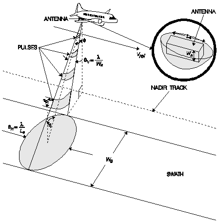
Figure 3. Geometry of a side-looking real aperture radar.
and so

where  is the incidence angle of the beam at the midpoint of the swath (equal to the look angle
  ) and Rm is the slant range (distance) from the antenna to the midpoint of the swath.
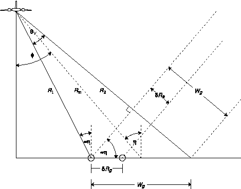
Figure 4. Range resolution of a side-looking real aperture radar.
Ground
resolution is defined as the minimum distance on the ground at which
two object points can be imaged separately, shown in Figure 4 as the
distance  Rg.
Two objects can be distinguished if the leading edge of the pulse echo
from the more distant object arrives at the antenna later than the
trailing edge of the pulse echo from the nearer object. Thus if their
distances to the antenna are different by at least half of the pulse
length (the distance the pulse travels in the time
Rg.
Two objects can be distinguished if the leading edge of the pulse echo
from the more distant object arrives at the antenna later than the
trailing edge of the pulse echo from the nearer object. Thus if their
distances to the antenna are different by at least half of the pulse
length (the distance the pulse travels in the time  p during which the transmitter is turned on) then the objects are resolvable. Therefore the ground range resolution is
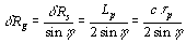
where Rg is the slant range resolution, is the incidence angle, Lp is the pulse length (in units of distance), p is the pulse duration (in units of time) and c is the speed of light. Note that as you approach the nadir line directly below the aircraft, approaches zero making sin()
approach zero so that the ground range resolution becomes extremely
poor. This makes sense since the objects near the nadir line are all
virtually the same distance from the antenna, making them impossible to
distinguish.
To achieve a ground range resolution small enough to be useful, the pulse duration çp would have to be too short to generate enough energy to produce a sufficient echo signal to noise ratio (SNR). To get around this, a technique known as pulse compression is often used together with a type of processing of the returned signal known as matched filtering (which we will not go into here, though a good description can be found in Curlander, see SAR References) to produce both high resolution and a high SNR. The ground range resolution possible with these techniques is

where BR is the frequency bandwidth of the transmitted radar pulse. The resolution can be further improved by increasing the frequency bandwidth.
Azimuth Resolution
Azimuth
is the direction parallel to the flight path of the aircraft. Figure 3
shows that the angular spread of the radar beam in the azimuth direction
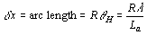
is equal to H = / La where is the wavelength of the transmitted beam and La is
the length of the radar antenna in the azimuth direction. This spread
is due to interference of the waves emitted from and received by the
dipoles of the antenna, which causes the angular spread to decrease as
the aperture length increases (a longer antenna produces a tighter beam,
much as a longer barrel of a gun produces less dispersion). Two objects
on the ground and with the same slant range R can only be imaged separately if they are not both within the radar beam at the same time. Thus the azimuth resolution is
Principles of Synthetic Aperture Radar
Because of the way in which microwaves interact with the atmosphere and the ground, only a select few frequency bands are useful for imaging. These are shown in Figure 5. The wavelength affects the penetration depth and also the size of a target necessary to return the radar. This shall be discussed later.
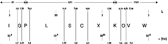
Figure 5. Microwave frequency bands useful for imaging.
For a specific frequency f (or wavelength ) and slant range R, the azimuth resolution is entirely dependent on the aperture length La.
However, for the altitudes at which satellite or airborne imaging
sensors operate (in the 1-10 GHz region), engineering difficulties make
it is impossible to achieve values of La / greater
than several hundred. For example, the new Canadian satellite RADARSAT,
launched in 1995, orbits at 792 km and operates at a frequency of 5.3
GHz (C-Band). The real aperture limit to the azimuth resolution would be
Through the use of synthetic aperture technology, however, RADARSAT can achieve a resolution as low as 9 m.
It was in 1951 that Carl Wiley first realized that the Doppler spread of the echo signal could be used to synthesize a much longer aperture (thus the name synthetic aperture radar) to greatly improve the resolution of a side-looking radar.
The Doppler Effect
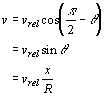
When a detector moves with respect to a source of waves, a shift in frequency is observed known as the Doppler effect. When a source emitting waves with frequency f recedes from the observer at a velocity v, the observed frequency is
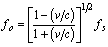
When the source approaches the observer, the observed frequency is
where v is always positive. Thus a receding source exhibits a lower frequency and an approaching source exhibits a higher frequency than the actual frequency emitted.
When two target points on the ground are separated in the azimuth direction, they are at slightly different angles from the antenna with respect to the line of flight. Because of this, they have slightly different speeds at any given moment relative to the antenna. Therefore the signal echoed from each target will have its frequency shifted a different amount from the original. To calculate the Doppler frequency shift for a specific target, refer to Figure 6 as we first calculate dR/dt--the relative speed with which the target and antenna approach each other.
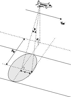
Figure 6. SAR geometry for calculating the Doppler frequency shift for a point target.
To find the R-directional component of Vrel (the velocity with which the target approaches the sensor), we can project Vrel (parallel to x) onto a line parallel to R to get
Now, we can calculate the frequency observed by the ground target:
-
科技前沿

-
产品技术
-
焦点事件

-
焦点事件

-
焦点事件

-
焦点事件

-
技术原理
-
技术原理